100 years ago this week Roald Amundsen and his boys hit the Transantarctic Mountains. They had always expected them to be there, extending from Beardmore Glacier, 200 miles to the north, where Shackleton had forged his route to the polar plateau in 1908, and where Scott this season would be pressing his men as well. Of course, the old idea of the Transantarctic Mountains petering out somewhere in the south was bantered about in Amundsen’s camp. Why not a straight shot from the ice shelf onto the plateau? But there was no doubt on November 8, when the first thin line of relief materialized at the horizon.

Hung with a stratus ceiling, the face of Mount Fridtjof Nansen looms in the shadows. As Amundsen’s party approached the mountains, this massif materialized with a grandeur surpassing all others.
As the party drew closer, the mountains took form, great blocky massifs set back from low, sinuous foothills. On Novermber 16 the party had left the level of the ice shelf and was camped on the rising undulation of the foothills. To the right was a smooth glacier that rose steadily to the south, but it appeared to head at the bottom of a gigantic massif, Mt. Fridtjof Nansen, as Amundsen named it., so that way was out. To the southeast the horizon dropped between Mt. Fridtjof Nansen and a bold peak to the left (east), Mt. Don Pedro Christophersen. Perhaps there would be passage there.

The 8,000 foot northern face of Mt. Fridtjof Nansen.
After dinner Amundsen and two of the others skied up into a col in the nearby range, deciding to head directly south over the ridge system at a reasonable spot. On the way back to camp Amundsen and Bjaaland skied over to a tiny nunatak (island of rock surrounded by snow) making the only bedrock landfall of the entire Antarctic portion of the expedition.

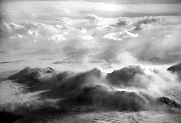
At the front of the photo, detached from its talon, the hooked claw of Mount Betty, Amundsen’s only landfall in Antarctica, connects through a gnarly eastern limb back to the massive body of Mount Fridtjof Nansen. Flanked to the south (left) by Axel Heiberg Glacier and to the west (right) by Liv Glacier, the central massif rises abruptly to an elevation of 13,350 feet along its shadowy, northeastern wall. Mount Don Pedro Christophersen is the dark, dome-shaped massif on the far side of Axel Heiberg Glacier. The pair of stepped icefalls between Mount Don Pedro Christophersen and Mount Fridtjof Nansen was the crux of Amundsen’s crossing of the Transantarctic Mountains. The route taken the first day in reconnaissance by Amundsen and Bjaaland is illustrated in blue. Amundsen’s route south, shown in magenta, links to the route on the following figure.
On November 17 the party covered 11 1/2 miles, rose 2,000 feet, and camped “on a little glacier among crevasses.” After dinner Wisting and Hanssen went in one direction and Bjaaland in another to scout a trail over the ridge crest.
The next morning, November 18, Amundsen chose the lower pass. As the party came out onto the crest of the ridge, the full faces of both Fridtjof Nansen and Don Pedro Christophersen presented themselves. Between the massifs was a pass with a short, steep glacier that cascaded down two ice falls separating terraces. Amundsen recounts, “we could follow a little connected line among the many crevasses; we saw that we could go a long way.”

Amundsen’s route through the Transantarctic Mountains winds purposefully across the foothills, up the icefalls of the Axel Heiberg Glacier, and behind Mount Engelstad, the low pyramid to the left of Mount Fridtjof Nansen. The first night’s camp “lay on a little glacier among huge crevasses.” The blue lines show the reconnaissance routes of Wisting and Hanssen to the right and Bjaaland to the left, with both parties reporting back that the next day they would have to descend. The steepest bit of climbing of the entire traverse was in the shadowed stretch of the ridge in the middle of the image. The Norwegians’ three camps at the base, middle, and top of the icefalls are indicated. The topmost in the gap to the left of Mount Engelstad was the “Butcher’s Shop.”
The party descended and then, hell bent on a southern heading, Amundsen chose to drive back up the next ridge rather than letting the party down onto the Axel Heiberg Glacier. By evening they had worked their way across the glacier and followed a deep, snow-filled furrow, and were camped beneath the shadowed face of Don Pedro Christopherson. Bjaaland and Hanssen skied up to the first icefall to scout a route, reporting back that they had found what appeared to be a way through.
November 19, As always on the more demanding ascents, Bjaaland was the forerunner, scouting the trail and leading the climb. The dogs double-teamed the sledges up the steep icefall, and the party managed to cobble a trail out of safe ground and solid bridges. Before midday they had reached the first terrace. The second icefall loomed ahead with “nothing but crevasse after crevasse, so huge and ugly” that this step was impassable. However, to the left, the terrace seemed to rise gently toward Mount Don Pedro Christophersen and to merge into its snowy lower slope. The men headed in that direction but soon found themselves in a cul-de-sac of open chasms, so they camped.

Map of the Axel Heiberg area showing Amundsen’s route through the mountains. Campsites are indicated with dots.
While the dogs were being fed and bedded, Amundsen led a reconnaissance sortie to the base of an ice ridge above the camp. The men returned to camp for dinner and then went out again to see what lay beyond the ridge. By keeping in close under Mount Don Pedro Christophersen, they found the passage over the ice ridge to be smooth, except for a few large, open crevasses that were easily avoided. Before long they were sure that they had passed the chaotic part of the glacier and that only one final ice rise stood between them and the plateau.
With confidence that they would be on the plateau the following day, the three men skied back to camp. As they came out on a rise and looked down at their tent, Amundsen reflected on the scene:
“Great blocks of ice scattered promiscuously about gave the impression that here Nature was too powerful for us. Here no progress was to be thought of.
“It was not without a certain satisfaction that we stood there and contemplated the scene. The little dark speck down there—our tent—in the midst of this chaos, gave us a feeling of strength and power. We knew in our hearts that the ground would have to be ugly indeed if we were not to maneuver our way across it and find a place for that little home of ours.”
On the morning of November 20, the weather was still and clear. The pull up to the next terrace was strenuous, but the dogs managed to do it with single teams. As the party rounded Mount Ole Engelstad, the plateau opened before. It was now time to turn south again. Directly ahead was a snowy ridge that projected to the west from Mount Don Pedro Christophersen. As they ran up onto it, the surface changed from the soft snow that had been with them since reaching the mountains to hard, sharp-edged sastrugi (windblown patterns in snow.) When the gratified party camped that night at 8:00 p.m., they were at 10,920 feet, having covered 19¼ miles and risen 5,750 feet. They had crossed the entirety of the Transantarctic Mountains in only four days. (Adapted from The Roof at the Bottom of the World.)